The plan was to fly into San Francisco, pick up this beast of a motorhome and take in stunning Lake Tahoe, then Yosemite National Park. We’d drift down to Death Valley before heading back to San Francisco along the Pacific Coast Road. Nigel would drive. I, not known for the best navigation skills in the world, would navigate.
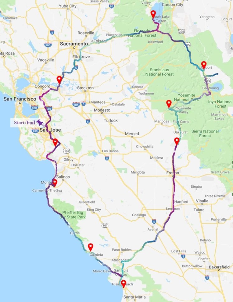
I’d barely had time to figure out how to unfold the massive State map, never mind read it, before we faced a bit of a medical emergency. It meant that Death Valley (and death, thankfully; this was minor) got the elbow. When you’re in a motorhome in California; route changes are easy–you just swap one jaw-dropping sight for another.

And it’s not just the heady altitude of some of the curling mountain roads through Yosemite National Park that leaves you gasping. It’s the scale of nature’s beauty: the deepest ravines; the sheerest, highest of granite rock faces, the most majestic, yet menacing birds of prey, soaring proprietorially above their domain.
Then, just when you think you’re through with dramatic intakes of breath as you brush the extreme edges of those high and tightly curling mountain passes, you’re round another bend and this time, the landscape’s laid out flat down in front of you. Miles and miles of panoramic beauty. The widest, driest, matte-gold plains. The gem-bright, glistening turquoise of Mono Lake. The desolate, dusty creepiness of Bodie.
Sights aside; this heavy heap of a motorhome on corkscrew bends was testing Nigel’s impressive handling skills– and his patience. While the series of maps we’d downloaded to a phone kept losing all road and place names. There were times when I was relying on sheer and shaky guesswork.
But if the going got tough; the tough got brewing. There was tea, and a kettle on board. And pretty much everything else we needed.
And luck was generally on our side–we’d only booked one campsite in advance; nearly all of the others we’d spotted on maps had spaces available, most with a firepit beside the pitch. Cooking in the open air turned every five dollar dinner into a gourmet delight under the stars.

We made sure we treated ourselves to a couple of restaurants along the way, too, and the chance to get off the road and just potter. We spent a day (but not the $299 a face cream salesman suggested I should part with to rid myself of my crows’ feet ) in the immaculately groomed town of San Luis Obispo. Great shopping, smart bars, restaurants and architecture.
Back on the road, we were starting to feel like seasoned camper-van professionals. We even got waved at by fellow roadsters from the same hire company as us. Unsure if this was ‘a thing’, we tended to return a rather bashful British smirk, instead, wishing we were zipping along in an open topped sports car, really. But the roads, thankfully, were never that busy. And although California’s big enough to dodge the tourists, sometimes, when a crowd is gathering by the roadside, it’s worth following their lead.
It happened half way back to San Francisco on the glorious Pacific Coast Highway. We spotted a group of people at a small car park near Lucia, beside what turned out to be a well established and proudly protected colony of elephant seals.

It didn’t take long before one, then two shiny, black-whiskered faces bobbed out of the foamy waves below. The huge and seemingly exhausted elephant seals lugged their heavy bodies towards the sand. Once clear of the water, they just lay there; still. Many of them, we learned, would have swum thousands of miles back to this point; diving down to 5,000 ft beneath the waves, to dodge their predators. Soon, they would wriggle their way a few more metres across the sand to join dozens more elephant seals resting in the shade.
We may have missed out on the sight and sound of big, brown bears in Yosemite National Park (although we had two encounters with coyotes)–but the seals more than made up for it. In their natural habitat, they were a hard act to follow for the thousands of beautiful sea creatures on carefully choreographed but captive display at Monterey’s impressive aquarium the next day.
Soon, it was time to edge further inland, back to the RV depot; Nigel at the wheel; me back on map duty. Did I know the way to San Jose, or preferably, around it, to beat the gridlock? Clearly not. But a (carefully concealed, I thought…) navigational gamble found us –surprisingly, and rather fortuitously for me–trundling over the impressive Dumbarton Bridge for a final glimpse of the sparkling waters surrounding San Francisco–that infamous ‘city by the bay’. After 1,100 wiggly miles, I’d just about got away with my latest ‘routing error’. Now a ten hour flight awaited us. One long haul. But at least someone else was at the ‘wheel’. And in charge of the map….

PS: A big thankyou to Simon Poulter, who knows this area really well, and offered some great recommendations for a suggested route for this trip–packed full of places of interest and snippets of info about each one. Wish we could have seen all of them–but the recommended stops we tried were brilliant…thanks, Simon!
